


11.5 km | 15 km-effort
![Trail On foot Červená Řečice - [Ž] Červená Řečice - Na vyhlídce - Photo](https://media.geolcdn.com/t/1900/400/d705b93f-8824-4978-8f66-916e162f23b1.jpeg&format=pjpeg&maxdim=2)

Tous les sentiers balisés d’Europe GUIDE+


FREE GPS app for hiking
 SityTrail
IGN / Geographical institutes
SityTrail World
The world is yours!
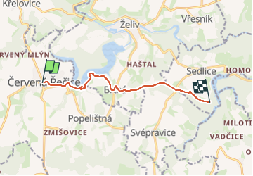
Trail On foot of 7.6 km to be discovered at Southeast, Kraj Vysočina, Červená Řečice. This trail is proposed by SityTrail - itinéraires balisés pédestres.
Trail created by cz:KČT.
ref číslo je ze starých rozcestníků
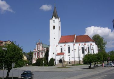
![Trail On foot Červená Řečice - [Ž] Červená Řečice - Na vyhlídce - Photo 1](https://media.geolcdn.com/t/2048/auto/1bb0bf2c-3b48-4bdf-824a-aa93c425daf5.jpeg&format=jpg&maxdim=0 "Trail On foot Červená Řečice - [Ž] Červená Řečice - Na vyhlídce - Photo 1")
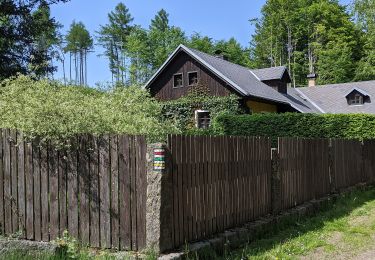
![Trail On foot Červená Řečice - [Ž] Červená Řečice - Na vyhlídce - Photo 2](https://media.geolcdn.com/t/2048/auto/2817c122-8386-4e27-add8-ad8ca8bbbf88.jpeg&format=jpg&maxdim=0 "Trail On foot Červená Řečice - [Ž] Červená Řečice - Na vyhlídce - Photo 2")
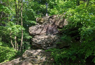
![Trail On foot Červená Řečice - [Ž] Červená Řečice - Na vyhlídce - Photo 3](https://media.geolcdn.com/t/2048/auto/dcba151f-38ec-409b-a75b-b0a76d9bdf67.jpeg&format=jpg&maxdim=0 "Trail On foot Červená Řečice - [Ž] Červená Řečice - Na vyhlídce - Photo 3")
![Trail On foot Červená Řečice - [Ž] Červená Řečice - Na vyhlídce - Photo 4](https://media.geolcdn.com/t/2048/auto/3484d120-7bee-4683-9840-ee35eacf1ae9.jpeg&format=jpg&maxdim=0 "Trail On foot Červená Řečice - [Ž] Červená Řečice - Na vyhlídce - Photo 4")
![Trail On foot Červená Řečice - [Ž] Červená Řečice - Na vyhlídce - Photo 5](https://media.geolcdn.com/t/2048/auto/1e00bc7f-2b8d-4b35-8fde-e97147eedbc9.jpeg&format=jpg&maxdim=0 "Trail On foot Červená Řečice - [Ž] Červená Řečice - Na vyhlídce - Photo 5")
![Trail On foot Červená Řečice - [Ž] Červená Řečice - Na vyhlídce - Photo 6](https://media.geolcdn.com/t/2048/auto/39ef2bea-bb3e-4ffb-8a5e-ebd6fdca9b89.jpeg&format=jpg&maxdim=0 "Trail On foot Červená Řečice - [Ž] Červená Řečice - Na vyhlídce - Photo 6")
![Trail On foot Červená Řečice - [Ž] Červená Řečice - Na vyhlídce - Photo 7](https://media.geolcdn.com/t/2048/auto/6219e680-3926-42d7-89ae-6b4b3a09c226.jpeg&format=jpg&maxdim=0 "Trail On foot Červená Řečice - [Ž] Červená Řečice - Na vyhlídce - Photo 7")
![Trail On foot Červená Řečice - [Ž] Červená Řečice - Na vyhlídce - Photo 8](https://media.geolcdn.com/t/2048/auto/a334de6e-aef6-435c-b639-cf6fdd5361cc.jpeg&format=jpg&maxdim=0 "Trail On foot Červená Řečice - [Ž] Červená Řečice - Na vyhlídce - Photo 8")
![Trail On foot Červená Řečice - [Ž] Červená Řečice - Na vyhlídce - Photo 9](https://media.geolcdn.com/t/2048/auto/edcf0e4c-1465-41a7-b6b6-83f2a554a2dc.jpeg&format=jpg&maxdim=0 "Trail On foot Červená Řečice - [Ž] Červená Řečice - Na vyhlídce - Photo 9")
![Trail On foot Červená Řečice - [Ž] Červená Řečice - Na vyhlídce - Photo 10](https://media.geolcdn.com/t/2048/auto/d705b93f-8824-4978-8f66-916e162f23b1.jpeg&format=jpg&maxdim=0 "Trail On foot Červená Řečice - [Ž] Červená Řečice - Na vyhlídce - Photo 10")
On foot
![Trail On foot Načeradec - [Ž] Načeradec - Dolní Královice - Photo](https://media.geolcdn.com/t/375/260/abc587a4-d8ff-40b4-bfd6-900f9bef250f.jpeg&format=jpg&maxdim=2)
On foot
![Trail On foot Trpišovice - [Ž] Melechov - Stvořidla - Photo](https://media.geolcdn.com/t/375/260/7bf805c9-ccf1-463d-aa80-df29d932aa38.jpeg&format=jpg&maxdim=2)
On foot
![Trail On foot Pelhřimov - [Č] Pelhřimov - Nový Rychnov - Photo](https://media.geolcdn.com/t/375/260/3b527b44-da93-45e2-822d-496afe7c79e4.jpeg&format=jpg&maxdim=2)
On foot
![Trail On foot Humpolec - [Ž] Humpolec - Kletečná - Photo](https://media.geolcdn.com/t/375/260/61c79774-ac44-4316-bc7b-59e2527b1d21.jpeg&format=jpg&maxdim=2)
On foot
On foot
![Trail On foot Nový Rychnov - [Z] Křemešnický okruh - Photo](https://media.geolcdn.com/t/375/260/f11d492b-ddb0-4c5d-b682-83aa126fd453.jpeg&format=jpg&maxdim=2)
On foot
![Trail On foot Humpolec - [Ž] Na Štůlách - Bysterská silnice - Photo](https://media.geolcdn.com/t/375/260/19fc1b13-afc2-4444-8232-ccf794b2b63e.jpeg&format=jpg&maxdim=2)
On foot
On foot